
Keyword
Earth Science | Oceans | Ocean Circulation | Ocean Currents
579 record(s)
Type of resources
Topics
Keywords
Contact for the resource
Provided by
Formats
Update frequencies
Status
draft
-
This dataset contains temperature and current data collected off Marmion, Perth, Western Australia between June 1982 and January 1986. Six surveys were carried out.
-
Model of Estuaries and Coastal Oceans (MECO) is a a three dimensional, non-linear, variable density, hydrodynamic model. It is intended to be a general purpose hydrodynamic model for estuaries and coastal oceans providing distributions of velocity, temperature and salinity as well as concentrations of passive tracers given input fluxes of water, passive tracers and forcing by winds, atmospheric pressure gradients, tides and surface heat fluxes. The equations forming the basis of the model are similar to those described in Blumberg and Herring (1987), except that the model uses z-coordinates, rather than sigma coordinates in the vertical. MECO is written in the C language, and uses the netCDF data format for input and output files. The MECO model has evolved into the Sparse Hydrodynamic Ocean Code (SHOC). SHOC has been in use since 2003 and is the hydrodynamic model used by the Coastal Environmental Modelling Team (CEM). Information regarding SHOC can be found at the CEM website. (please see link below)
-
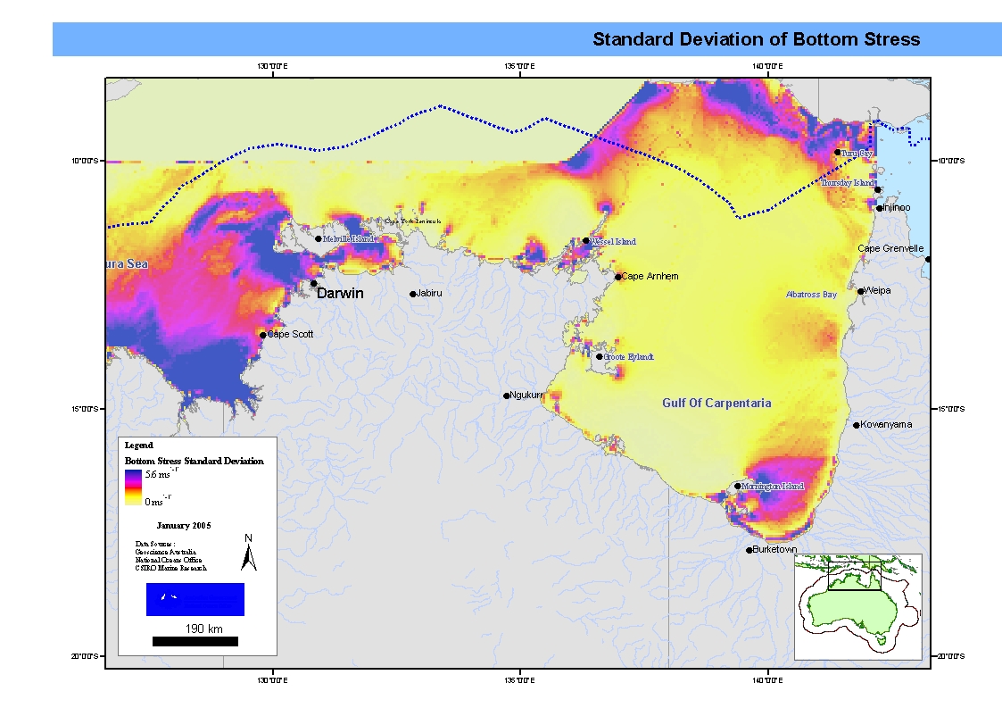
Mapset showing maximum, mean and standard deviation bottom stress in the Northern Marine Region. This map has been produced by CSIRO for the National Oceans Office, as part of an ongoing commitment to natural resource planning and management through the 'National Marine Bioregionalisation' project.
-
Geostrophic subsurface currents computed directly from geopotential anomaly, with Lagerlof et al. (1999) equatorial treatment. Computed from CARS2000 3-dimensional seasonal temperature and salinity fields. Monthly values derived from annual and semi-annual temperature and salinity cycles. CARS is a set of seasonal maps of temperature, salinity, dissolved oxygen, nitrate, phosphate and silicate, generated using Loess mapping from all available oceanographic data in the region. It covers the region 100-200E, 50-0S, on a 0.5 degree grid, and on 56 standard depth levels. Higher resolution versions are also available for the Australian continental shelf. The data was obtained from the World Ocean Atlas 98 and CSIRO Marine and NIWA archives. It was designed to improve on the Levitus WOA98 Atlas, in the Australian region.
-
The Northern Region Circulation Model was developed as part of the FRDC Surrogates 1 project. It covers the region from Joseph Bonaparte Gulf to Torres Strait with a fixed horizontal resolution of 0.05 degrees. Outputs included sea level, currents, bottom stress, and other physical parameters. For this dataset the maximum current velocity (max u & V) were used to create GIS map layers
-
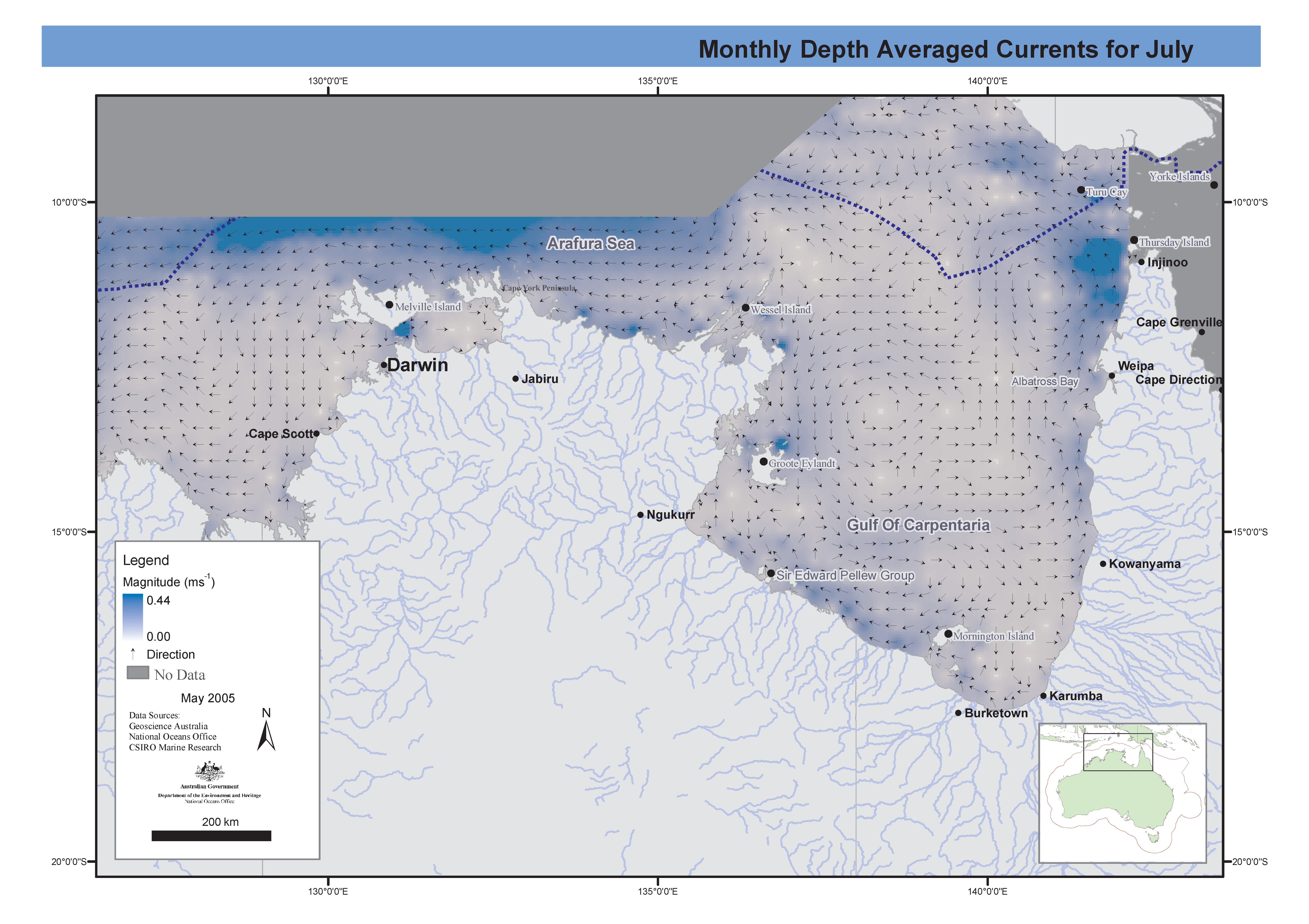
Set of maps showing currents in the Northern Marine Region for the wet (January) and dry (July) seasons. These maps have been produced by CSIRO for the National Oceans Office, as part of an ongoing commitment to natural resource planning and management through the 'National Marine Bioregionalisation' project.
-
The Northern Region Circulation (MECO) Model was developed as part of the FRDC Surrogates 1 project. It covers the region from Joseph Bonaparte Gulf to Torres Strait with a fixed horizontal resolution of 0.05 degrees. Outputs included sea level, currents, bottom stress, and other physical parameters. For this dataset the monthly mean non tidal currents for the Northern Marine Region were used to create GIS map layers.
-
The Northern Region Circulation Model was developed as part of the FRDC Surrogates 1 project . It covers the region from Joseph Bonaparte Gulf to Torres Strait with a fixed horizontal resolution of 0.05 degrees. Outputs included sea level, currents, bottom stress, and other physical parameters. For this dataset the maximum current velocity (max u & V) were used to create GIS map layers
-
The Northern Region Circulation (MECO) Model was developed as part of the FRDC Surrogates 1 project. It covers the region from Joseph Bonaparte Gulf to Torres Strait with a fixed horizontal resolution of 0.05 degrees. Outputs included sea level, currents, bottom stress, and other physical parameters. For this dataset the monthly mean non tidal currents for the Northern Marine Region were used to create GIS map layers
-
ENACT - ENhanced ocean data Assimilation and ClimaTe prediction - Ocean reanalysis dataset 1962-2004
The ENACT (Enhanced ocean data Assimilation and ClimaTe prediction) datasets are global ocean reanalysis datasets created by assimilating timely observational data into a numerical ocean circulation model (HOPE-E). ENACT was created as a part of the European Commission Framework 5 project motivated by the requirement to provide a detailed estimate of the ocean state at a particular time, providing gridded temperature, salinity, and velocity information. The CSIRO version of the ENACT dataset is a concatenation of the individual monthly variables Potential temperature, Seawater x-velocity & Seawater y-velocity into single netcdf files for the time period 1962-2004 with a spatial resolution of 1.0° x 1.0° at 33 depths. It has also been processed to include calculated anomaly, climatology, and seasonal forms of this data.